



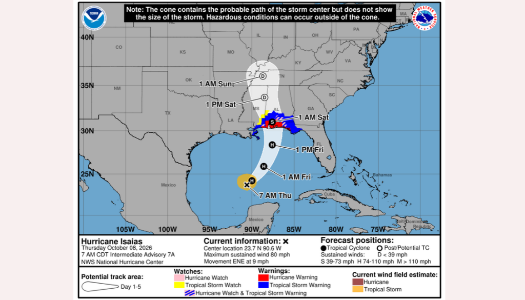
Hurricane Isaias has strengthened into a Category 1 hurricane in the Gulf of America, with the latest forecast indicating a possible landfall along the Florida Panhandle Friday night.
Although the storm’s projected landfall is west of Jeff Davis County, residents across Southeast Georgia should prepare for the possibility of heavy rainfall, gusty winds, localized flooding and isolated tornadoes as tropical moisture moves into the region this weekend.
According to the National Hurricane Center’s 5 a.m. Thursday advisory, Isaias had maximum sustained winds of 80 mph and was moving east-northeast at approximately 9 mph. The storm’s central pressure was reported at 979 millibars.
Hurricane Hunter aircraft confirmed that the storm had continued to intensify, prompting increased attention to potential impacts along the northern Gulf Coast.
The forecast calls for Isaias to approach the Florida Panhandle Friday night. However, tropical systems can produce dangerous weather well away from their centers, including heavy rainfall and tornadoes.
What Jeff Davis County Can Expect
The latest forecast for Hazlehurst indicates that Thursday should remain relatively quiet before rain chances increase Friday and continue into the weekend.
Thursday, October 8: Partly sunny to mostly cloudy skies are expected, with a high near 83 degrees. Rain chances remain low throughout most of the day.
Friday, October 9: Clouds will increase, with a high near 74 degrees. Showers may begin developing during the afternoon, with rain becoming more likely Friday night.
Saturday, October 10: Saturday currently appears to present the greatest potential for tropical rainfall across Jeff Davis County. Periods of heavy rain, thunderstorms and localized flooding are possible. Isolated tornadoes may also be a concern as the system affects the region.
Sunday, October 11: Additional showers and thunderstorms remain possible, with flooding concerns continuing in areas that receive substantial rainfall.
The timing and severity of local impacts will depend on the hurricane’s eventual track and how its rain bands develop.
Homecoming Football Game Moved Ahead of Weather
Jeff Davis High School’s homecoming football game against Bacon County, originally scheduled for Friday, October 9, was moved to Thursday, October 8, because of the potential for deteriorating weather conditions.
Thursday’s forecast currently looks considerably more favorable for outdoor activities than Friday night and Saturday.
Although Jeff Davis County is not currently forecast to experience a direct hurricane landfall, residents should remain alert to changing weather conditions. Heavy tropical rainfall can quickly overwhelm drainage systems, flood low-lying roads and create dangerous driving conditions. Gusty winds and thunderstorms may also produce isolated power outages.
Residents are encouraged to secure loose outdoor items, charge electronic devices, review emergency plans and avoid driving through flooded roadways. Those living in areas prone to flooding should pay particular attention to updated forecasts and any advisories issued by local emergency officials.
Forecast Could Still Change
Hurricane forecasts are continually updated as new information becomes available. Even relatively small changes in the storm’s track or speed could affect the timing and severity of weather across Southeast Georgia.
Hazlehurst Now will continue monitoring Hurricane Isaias and providing updates as additional information becomes available from the National Hurricane Center and National Weather Service.
Residents can follow official forecasts at www.nhc.noaa.gov and www.weather.gov/jax.
Source verification: The National Hurricane Center’s October 8 morning advisory confirms Isaias had 80 mph sustained winds, was moving east-northeast at 9 mph, and had a minimum pressure of 979 mb.

The local day-by-day outlook is based on the Thursday morning forecast for Hazlehurst.
