









Tropical Storm Isaias is gaining strength in the Gulf of America, and communities across the Southeast are beginning to make preparations ahead of possible impacts later this week. Locally, Jeff Davis has already moved its homecoming football game against Bacon County from Friday night to Thursday night due to the potential for weather associated with the storm.


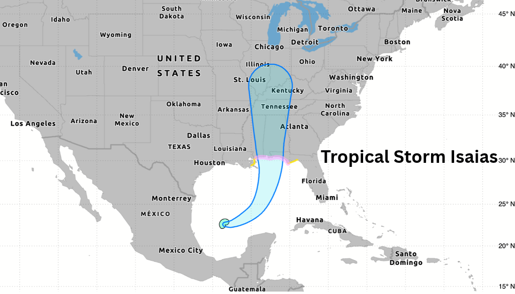
As of the National Hurricane Center’s 1 p.m. CDT update Wednesday, Isaias had maximum sustained winds of 50 mph and was moving east-northeast at approximately 8 mph. NOAA Hurricane Hunters found the storm strengthening, with its central pressure falling to 997 millibars. Isaias Expected to Become a Hurricane
Forecasters expect Isaias to continue strengthening as it moves across the Gulf and become a hurricane before approaching the northern Gulf Coast late Friday. Hurricane and storm surge watches have now been issued for portions of the northern Gulf Coast. A Storm Surge Watch extends from the mouth of the Mississippi River eastward to Yankeetown, Florida. The National Hurricane Center cautions that residents should not focus only on the exact center of the forecast track, as impacts can occur well away from the center.


While Jeff Davis County is not currently in the expected landfall area, Isaias could still influence our weather as it moves inland. Forecasters across Georgia are increasingly watching for heavy rainfall, gusty winds and the possibility of isolated tornadoes as moisture associated with Isaias spreads across the region. Exactly where the heaviest rain and strongest winds occur will depend heavily on the storm’s eventual track.
Closer to Southeast Georgia, forecasters are currently projecting roughly 1 to 2 inches of rain for portions of Southeast Georgia and the Lowcountry this weekend, although those amounts could change as the track becomes clearer.
For now, Thursday appears to be the better window locally, with deteriorating weather becoming more of a concern heading toward Friday and the weekend.
There remains considerable uncertainty in the forecast. Isaias is still several days from its expected Gulf Coast landfall, and relatively small changes in its track could significantly alter which areas experience the greatest rainfall, wind and severe-weather threat.
For that reason, Southeast Georgia residents should continue monitoring forecasts rather than relying on any single model run or forecast graphic. The next 24 hours should provide a much clearer picture as additional Hurricane Hunter data is incorporated into forecasts and Isaias becomes better organized.
Hazlehurst Now will continue monitoring the storm and will provide another local update Thursday as the forecast for Jeff Davis County becomes clearer.
Track Isaias with the National Hurricane Center
Sources: National Hurricane Center, WJCL


